by Mike Krabach www.krabach.info
Rhode Island Canoe/Kayak Association www.rickaseakayaking.org
Videos are all in 4K 60fps format, although your screen resolution and bandwidth will determine the resolution you see. (A 4K monitor or TV is required to view in 4K.) For viewing on any smart TV, use the Youtube App and search for for @mkrabach3.
For full descriptions and links for these Ricka paddles, and similar non-Ricka paddles, use this index page. Or jump right to the Ricka videos with the links below.
Below for each paddle is an [Index] and [Map]. The [Index] will link to an album index of thumbnails. That page will have links, in most cases, an [Overview] link for a map page, and a [Trip Listings] link. (The [Index] is obviously dead on the thumbnail page.) Earlier albums use the term "Thumbnail", interchangeable with [Index].
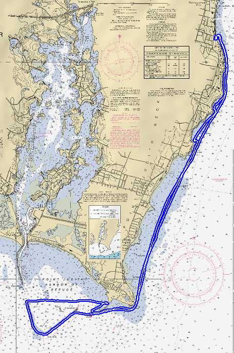
The [Overview] map pages have location maps of the paddle. There are clickable red buttons for photo locations, or shaded boxes that link other detailed maps, also with buttons. If the route is confusing, red buttons are the outgoing route and the magenta buttons are the returning route. Photos do not have captions, just a cryptic date, so the [Overview] maps are the only indication of the route. For later albums, no buttons, just the route is shown. Because modern laptops and monitors do not have the same aspect ratio as the photos, be aware that navigation links maybe at the bottom of the page and not seen.
After all the navigation updates listed above, many older albums still have limited navigation links. The back arrow/button may be needed to return from a red button link to the [Overview] page. Use [Alt <=] to go back on a computer or use the back link on a smartphone or tablet.
Photos before 2007 were digitally scanned Nikonos film images. After 2007 an Olympus 1030SW waterproof digital camera was used.
Some of the more interesting paddles are highlighted. These include iconic Bay paddles and a few more adventurous paddles.
For a sampling of a select few of the Ricka day trips listed below, use the this [map page]. Click on the indicated red shaded areas in the map.
June 10, 2001 -- Galilee to end of Point Judith Pond [Index] [Map]
August 25, 2001 -- South Ferry to Dutch Island to Beavertail Point [Index] [Map]
September 3, 2001 -- South Ferry to Jamestown Bridge to Plum Beach [Index] [Map]
September 15, 2001 -- Mystic River to Mystic Seaport to Rams Island [Index] [Map]
September 16, 2001 -- Kings Beach around Lands End to Second Beach Newport [Index] [Map]
September 22, 2001 -- Jamestown Beach to Castle Hill to Brenton Reef [Index] [Map]
October 13, 2001 -- Bristol to Wickford Harbor [Index] [Map]
October 20, 2001 -- Fairhaven to around West Island [Index] [Map]
November 4, 2001 -- Cambridge to Boston Harbor Waterfront [Index] [Map]
November 10, 2001 -- Newport 3nd Beach Sakonnet River [Index] [Map]
July 7, 2002 -- South Ferry to Jamestown to Beavertail to Bonnet Shores [Index] [Map]
July 14, 2002 -- Bristol Harbor to Mt Hope Bridge to Fall River [Index] [Map]
July 20, 2002 -- Quonset Point to Allen Harbor to Hope Island [Index] [Map]
August, 2002 -- Dutch Island exploration [Index] [Map]
August 3, 2002 -- Save the Bay Swim (Not a Ricka event) [Index] [Map]
August 4, 2002 -- Narragansett Pier to Point Judith Harbor [Index] [Map]
August 14, 2002 -- Ft Wetherill to Coddington Cove to Rose Island [Index] [Map]
August 24, 2002 -- Mystic Harbor around Mason Island [Index] [Map]
September 8, 2002 -- Narragansett Pier to Castle Hill to Mackerel Cove [Index] [Map]
September 14, 2002 -- Lynch Park, Beverly, Mass. To Great Misery Island [Index] [Map]
September 21, 2002 -- Bristol Narrows to Battleship Cove [Index] [Map]
September 22, 2002 -- King's Beach to Second Beach Newport [Index] [Map]
September 29, 2002 -- Fogland Beach Tiverton to Third Beach Newport [Index] [Map]
October 6, 2002 -- Wilson Park Wickford to Bissel Cove to Quonset Pt. [Index] [Map]
October 27, 2002 -- Cambridge to Boston Harbor Waterfront [Index] [Map]
May 17, 2003 -- Ninigret Pond to East Beach, Charlestown [Index] [Map]
June 15, 2003 -- URI Bay Campus foggy paddle to Dutch Island [Index] [Map]
June 21, 2003 -- Sakonnet Harbor, East towards Horseneck Beach [Index] [Map]
June 29, 2003 -- URI Bay Campus to Beavertail to Whale Rock [Index] [Map]
July 5, 2003 -- Kings Beach, Eastward Level 4 Attempt... [Index] [Map]
July 6, 2003 -- Barn Island to Fishers Island get together [Index] [Map]
July 13, 2003 -- South Ferry to Jamestown Bridge to Rome Pt [Index] [Map]
July 20, 2003 -- Ft. Wetherill paddle around Jamestown Island [Index] [Map]
August 23, 2003 -- Loop around Great Salt Pond at Point Judith [Index] [Map]
August 24, 2003 -- Island Hop in East Passage from Ft. Wetherill [Index] [Map]
August 31, 2003 -- Pier5, Narragansett to Castle Hill, Newport [Index] [Map]
September 6, 2003 -- South Ferry to Mackeral Cove, Jamestown [Index] [Map]
November 2, 2003 -- Heads Beach, Jamestown to Prudence Island [Index] [Map]
June 26, 2004 -- Jamestown Island Circumference Paddle [Index] [Map]
July 3, 2004 -- Heads Beach, Jamestown to Prudence Island [Index] [Map]
July 18, 2004 -- South Ferry to Black Point, Narragansett [Index] [Map]
July 25, 2004 -- Sakonnet Point, Fishing Paddle to Briggs Beach [Index] [Map]
August 7, 2004 -- Slocums River, Paddle and Swim to Allens Pond [Index] [Map]
August 8, 2004 -- Narragansett, to Castle Hill and CG Station [Index] [Map]
August 14, 2004 -- Bristol Harbor to Prudence Island [Index] [Map]
October 2, 2004 -- Ft. Wetherill to Newport Harbor Cruise Ships [Index] [Map]
October 9, 2004 -- Heads Beach to Beavertail Point [Index] [Map]
April 16, 2005 -- Ft Getty to Beavertail and Dutch Island [Index] [Map]
May 28, 2005 -- Sakonett Point to East to Elephant Rock Beach[Index] [no Map]
May 30, 2005 -- Spinks Neck Beach, Davisville to Prudence Island [Index] [Map]
June 18, 2005 -- URI to Rome Pt and up West Passage [Index] [Map]
June 19, 2005 -- Bristol Harbor and around Prudence Island [Index] [Map]
July 3, 2005 -- Goddard Park to Warwick Fireworks at Buttonwood Park [Index] [Map]
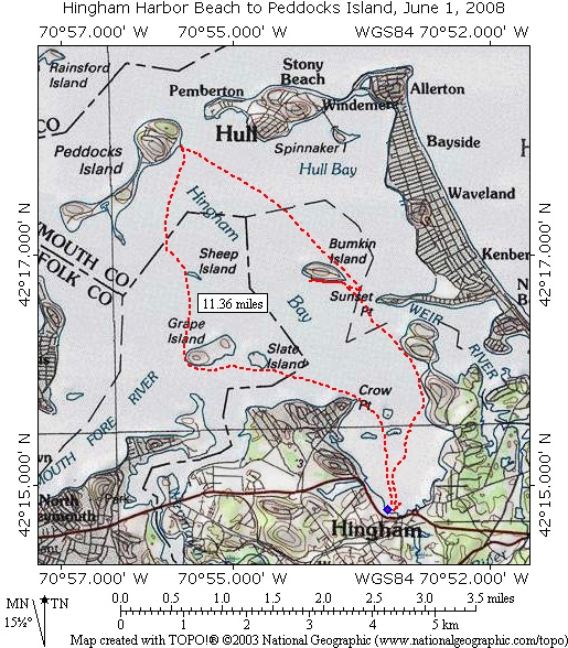
July 10, 2005 -- Hingham Harbor to Peddocks Island in Mass. Bay [Index] [Map]
July 16, 2005 -- Kings Beach Foggy Day to Easton Bay, Newport [Index] [Map]
July 17, 2005 -- Barn Island Foggy Day to Dodges Island, Mystic [Index] [Map]
July 30, 2005 -- Slocums River to Allens Pond, Dartmouth [Index] [Map]
August 6, 2005 -- Pier 5 to Galilee Beach and Pt Judith Harbor [Index] [Map]
August 7, 2005 -- Ft Wetherill paddle to Brenton reef and Sheep Pt Cove, Newport [Index] [Map]
August 13, 2005 -- Ft Wetherill circumferential paddle around Jamestown Island [Index] [Map]
August 20, 2005 -- Jamestown, Gould and Rose Island Hop in East Passage [Index] [Map]
August 19, 2006 -- Haines Park to Bristol Town Beach with Waves [Index] [Map]
August 27, 2006 -- Ft. Wetherill to Newport Harbor Wooden boat show [Index] [Map]
September 9, 2006 -- Ft. Wetherill Island Hop with Coddington Cove diversion [Index] [Map]
October 8, 2006 -- Rye Harbor, NH to Isles of Shoals open ocean paddle [Index] [Map]
October 21, 2006 -- Westport Harbor and East Branch with lunch on white rock [Index] [Map]
November 4, 2006 -- Magazine Park to Barking Crab Restaurant, Boston Harbor [Index] [Map]
December 3, 2006 -- 3rd Beach, Sachuest Pt. to Ochre Pt. Newport [Index] [Map]
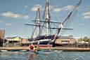
June 30, 2007 -- Ft. Wetherill to Tall Ships in Newport Harbor [Index] [Map]
August 11, 2007 -- Heads Beach to Dutch Island Fortifications and beyond (missing some originals)[Index] [Map]
August 25, 2007 -- Barn Island, Stonington to Ram Island and back [Index] [Map]
September 23, 2007 -- Rye Harbor, NH to Isle of Shoals off shore paddle. [Index] [Map]
September 30, 2007 -- Westport Harbor to Gooseberry Neck and over Horseneck Beach [Index] [Map]
October 7, 2007 -- Charles River paddle to Barking Crab Restaurant in Boston Harbor [Index] [Map]
June 1, 2008 -- Hingham Harbor Beach to Peddocks Island. (Photos lost) [Index] [Map]
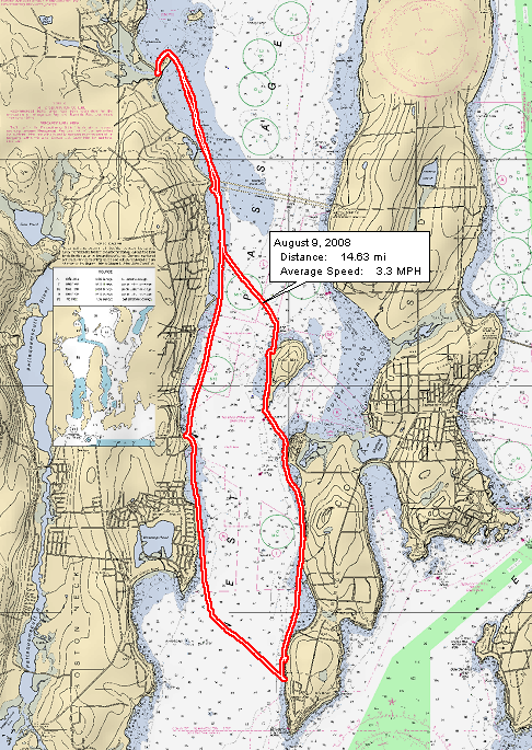
August 9, 2008 -- URI Bay Campus to Rome Pt. to Beavertail. (Photos lost) [Index] [Map]
August 10, 2008 -- Pier 5 to Pt Judith Beach. (Photos lost)[Index] [Map]
October 12, 2008 -- Gooseberry Island to Baker's Beach Club [Index] [Map]
October 26, 2008 -- Solders Field paddle to Barking Crab in Boston Harbor [Index] [Map]
July 12, 2009 -- Sakonnet Point Rock Gardening. [Video]
Sept. 15, 2009 -- Neponset River to Boston Harbor, Ft. Warren and Boston Light. [Index] [Map]
October 6, 2009 -- Upper Sudbury River Fall Paddle toward Framingham. [Index] [Map]
October 25, 2009 -- Kayaking Ocean Swells off Jamestown, RI . [Video]
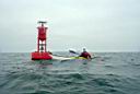
June 26, 2010 -- URI Bay Campus to Bell Buoy "NR" south of Beavertail Point. [Index] [Map]
August 1, 2010 -- Kings Beach for Rock Gardening around islands and shoals off Newport, RI. [Index] [Map]
August 9, 2010 -- Pier 5 Narragansett to Pt. Judith to Harbor of Refuge. [Index] [Map]
August 21, 2010 -- Gooseberry Neck, Westport, to Cuttyhunk and back. [Index] [Map]
September 11, 2010 -- Kayaking from 3rd Beach, Newport, to Sakonnet Point. [Video] [Map]
September 18, 2010 -- Waiting for Hurricane Igor. [Video] [Map]
May 20, 2012 -- Kings Beach, Rock Gardening along Newport Neck coast. [Video] [Map]
Sea Kayaking videos during the years 2008-2012.
These are above listed videos but in a single page for easy viewing. Video cameras in the past were quite crude compared to those available now. So excuse the quality of the listed paddles.
Coastal Access for Kayaking [text], or [Coastal Access Map]
Panoramic Photo of URI Bay Campus Beach, one of the most popular launch sites for RICKA sea kayaking.
Sakonnet rock gardening video frames.