Local
Coastal Access Information
(Most
links keep same window, use <= to return)
Rhode Island Public Access
For a complete guide to public coastal access sites suitable for kayak launching in Rhode Island, link to the Coastal Access Map or to the Text Version. This new Coastal Access Map is based on information from “A Daytripper's Guide to Rhode Island” and other public sources.
RI State and Town public boat ramps to salt water (and freshwater) are listed by the RI DEM
For b&w aerial photos of anyplace in RI (including coastal areas), link to the Rhode Island Ortho Server, or the Maptech MapServer which uses the same derivative 1995 aerials.
Maptech is easier to search by town, place name, or lat-long, and covers other States besides RI, but has fixed 500x500 pixel aerial photos at various scales. Maptech has four types of maps; USGS topographic, marine maps, aviation maps, and aerial photos. It is a commercial site with many nice features.
The URI Ortho Server is a Rhode Island public service and offers three options: RI USGS 1:24,000 topographic maps, and 1:12,000 and 1:5,000 aerial photos. The two aerial photo sets are from different flights. The maps and photos only cover RI and can only locate an area by using a combination of cursor pointing and scaling buttons, but the resolution at 1:12,000 is twice Maptech's 1:24,000 and the dimensions (in pixels) of a photo are scalable, so larger and more detailed aerials are can be viewed as compared to Maptech. The 1997 Ortho Server at 1:5000 scale shows even more detail, although somewhat fuzzy with less contrast.
Massachusetts Public Access
For the Greater Boston Harbor and North Shore access, link to the “Massachusetts Office of Coastal Zone Management”. Developed by the Massachusetts Office of Coastal Zone Management (CZM), the Massachusetts Coast Guide describes nearly 400 public access sites from Salisbury to Hingham, ranging from expansive parks to small public landings and out-of-the-way spots. You can order a free printed version of the Coast Guide which has 80+ pages of information, including 22 maps.
The Massachusetts CZM has developed a more inclusive “Online Locator of Coastal Public Access Sites” for publicly accessible coastal properties. This includes access to the southeastern Massachusetts and Cape Cod sites not available in the above reference. The site is interactive but requires learning to manipulate. You can zoom into the maps for greater detail, eventually showing local roads. Accessing the site is very very slow if you don't have broadband access. Some locations have photos , but the images are huge (1-2 MB) amateurish photos. (Evidently the creators did not think enough to reduce them to web size. A 1.5 MB picture of a large empty concrete parking lot can be reduced to a more appropriate 50KB.) Note that in some detail maps, the red “Small Public Access Sites” icons are lost behind street labels. Some launch sites within State and National Parks not listed.
Tip: Site uses layers of maps (transparent to you), so you must first click on 'Basic or Advanced Tools' icon to set up the operation (do not close any popup window that comes up) before clicking on the map for that feature.
The Massachusetts Department of Fish and Game has fishing and boating access for inland and coastal sites listed at the “Public Access Board”. Clicking on a numbered site on a general map (a little hard to read) gets a sortable table of access sites. The only information available is type of ramp, who owns it and suitability of ramp for small boat launching. Each site has a link to a pdf map showing major roads around the launch site.
Massachusetts launch sites near Rhode Island are also on the Coastal Access Map.
Access issues, fees and public access to the ocean are discussed on this page for Boat Ramps & Boat Launches in Buzzards Bay. The "Buzzards Bay National Estuary Program" site has other useful information on ocean waters within their juristiction.
For aerial photos of the Massachusetts Coastline, the original MIT coastal site is no longer available. Instead for b/w aerial photos of 1:5000 scale, which are half meter accuracy, the best site is MassGISBWOrthos where the user can select any place in Massachusetts including the coastal areas. The viewer is easy to use, but the even the index map (700K) is large, so dial-up access is slow, but broadband access is fine. The site uses a framed page, therefore scripted URLs will not work to predefine a specific area, so launch sites will have to be found by searching. There is also a color version of the viewer at MassGISColorOrthos.
Connecticut Public Access
For Connecticut, link to the “Connecticut Coastal Access Guide”, now linked to a new (2004) improved site in conjunction with the Univ. of Conn. The printed July 2001 edition Guide is available by mail free, see the same web page. Also read a legal note on the Connecticut Intertidal Zone.
Connecticut launch sites near Rhode Island are also on the Coastal Access Map..
Free Marine Charts
Free Marine Coastal Charts, and viewers are available. NOAA has free digital maps that can be downloaded and various companies have free viewers. Some viewers can manage both vector (ENC) maps and raster (RNC) maps. If you want more information on the subject, see the Electronic Navigational Charts page for nautical maps of many regions including those of our area, and opinions on viewers available. Some viewers allow printing the maps, but others will need a screen capture program to save the image, and then print it. If you don't have the inclination for technical details, use one of the following methods for viewing marine maps.
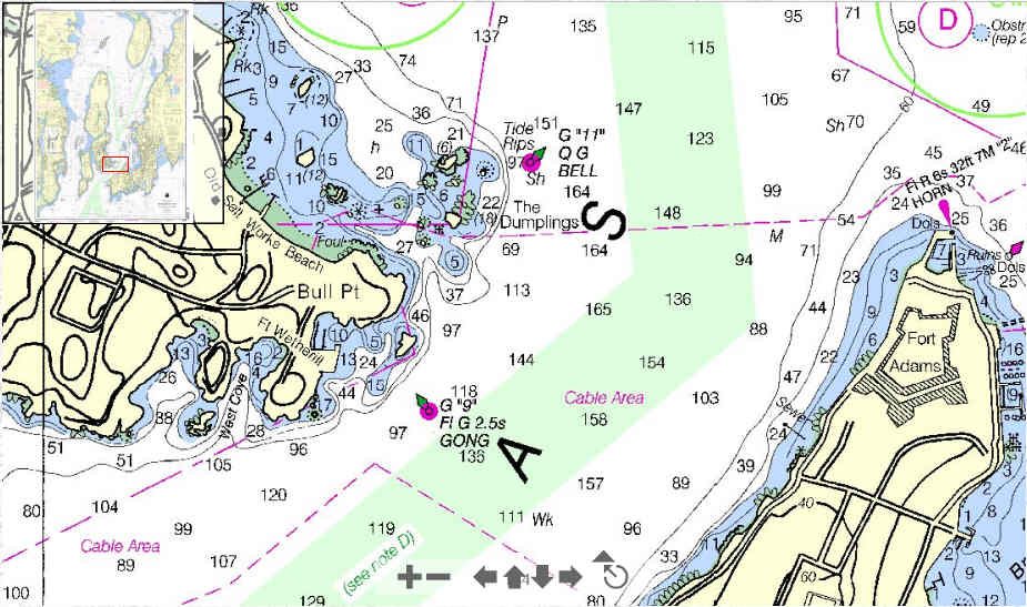
On-Line raster maps and an 'easy to use' viewer are available from NOAA. (If you have dialup internet, forget about using this site, megabytes of data are transfered.) The Atlantic Region is a list of maps, that are linked to the viewer, which automatically displays that region. You will need the Adobe Flash Player Plugin installed (if you can view YouTube, you have it) to see the maps. All the maps can be zoomed and panned, but are limited by size to 925 x 550 pixels. (Sample at full resolution) There is no way to print the on-line map, but you can use a screen capture program to save the image, and then print it. Some of the maps for the Narragansett Bay region are listed in the following table. You can click on the chart number in the table to view that marine chart. (Charts will open up in a new window.)
| CHART | SCALE | TITLE |
| 13214 | 20000 | Fishers Island Sound |
| 13215 | 40000 | Block Island Sound Point Judith to Montauk Point |
| 13217 | 15000 | Block Island |
| 13218 | 80000 | Martha's Vineyard to Block Island |
| 13219 | 40000 | Point Judith Harbor |
| 13221 | 40000 | Narragansett Bay |
| 13223 | 40000 | Narragansett Bay, Including Newport Harbor |
| 13224 | 20000 | Providence River and Head of Narragansett Bay |
| 13225 | 10000 | Providence Harbor |
| 13226 | 20000 | Mount Hope Bay |
| 13227 | 2000 | Fall River Harbor;State Pier |
| 13228 | 20000 | Westport River and Approaches |
Online Mapping software by Geogarage has a demo World map with marine charts of United States coastal areas, including the Gulf Of Mexico and the Great Lakes. (If you have dialup internet, forget about using this site, megabytes of data are transfered.) Google satellite images and street maps are overlain with NOAA marine charts. You have control of the tranparency of the overlays. (Sample World map) For more information about the site and how to use it, link to this page. As useful as this site is, it is still a demo site and may not be available in the future. Note that the Delorme GPS PN-20 and PN-40 and other full feature GPS's can do the same thing as Geogarage but on a much smaller screen. The disadvantage is you will have to purchase propriatory maps designed for your specific GPS. But the GPS is portable and waterproof for use in the marine environment, whereas the Geogarage system requires a computer browser and access to the internet. (Mobile PDAs in the marine environment may not be a good idea, not withstanding their portability.) Sometimes purchasing a commercial marine chart, waterproof and alot larger, is more useful. (The demo will open up in a new window.)
Marine/General Weather Forecast
For the latest marine weather forecast (wind and seas, no temperatures) for the bays and coastal areas, link to the National Weather Service.
For the latest general weather forecast for New England, link to the NOAA Boston page.
Present Weather and Oceanographic Conditions
To see the present and past 24 hr offshore (sample data) wave data and meteorological data (good indication of coastline wave height) from NOAA link to the Buzzards Bay Buoy. Other Regional New England locations can be accessed from this coastal map.
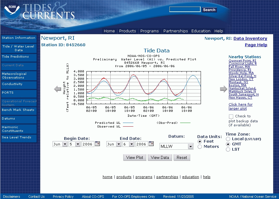
To see the present air and water conditions in Narragansett Bay showing 48 hr realtime plots (sample plots) of air [temperature/pressure/speed/direction], and water temperature (only at Newport, Conimicut, Providence) and tides, link to NOAA . For oceanographic data for locations anywhere in the USA, look at the CO-OPS main page.
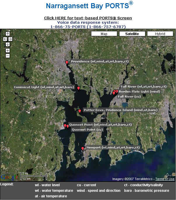
For a quick look at the present wind and air conditions at six locations in the Bay (sample map) link to the [Physical Oceanographic Real Time System] PORTS map. For detail 3 day charts, meteorological and oceanographic data for any of the PORTS stations (sample map) in the Bay, link to the Narragansett Bay PORTS. (which now uses Google Maps, dialup takes over 4 minutes.) For a snapshot of all stations in real time, link to the text version of PORTS. Also available is a nice composite chart (sample chart) of conditions in the middle of the Bay at Quonset Point.
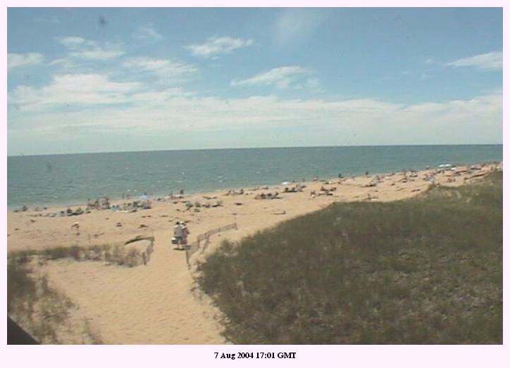
For very complete offshore meteorological and oceanographic data (sample composite weekly plots) off the south shore of Martha's Vineyard, link to WHOI. They also have a shoreline webcam. (Javascript must be enabled.) You can judge relative wave size from March surf or people in July.
For a graphical offshore map of links and locations of the above, click on the buoy map.
For semi-monthly average (and present) water temperatures in New England (sample data) link to the National Oceanographic Data Center. Helps you define the warmer kayaking season.
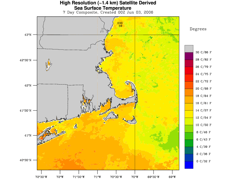
For satellite IR water surface temperatures for Southern New England, look at the new NOAA (sample data) Sea Surface Temperature page. Click on the table item you want to view for a 7 day composite image. More specific daily images from each satellite over the East Atlantic Coast (real time, incl. Cape Cod) (sample image) is the link to Rutgers Univ. For a beautiful image of the whole North Gulf Stream (from Cape Hatteras to Newfoundland) (sample image) link to Live Weather Images. For “more-than-you-ever-wanted-to-see” satellite images, link to this main page or try NASA.
For Rhode Island tidal data in chart form, (sample chart), showing RI Hi/Lo/Sunrise/Sunset predictions for the current month and 5 months ahead, link to the MaineHarbors. For Massachusetts link to BoatsMa.com. For New Hampshire and Maine, link to MaineBoats and click on the map. For Connecticut, try Tidesonline.
For quick Hi/Low/Sunrise/Sunset predictions for any day or days of the year, with many options, link to U of SC (big text page, search with [Ctrl+F] to find Rhode Island sites). This site is best for finding the tides and currents (sample page) for interpolated stations other than the primary tidal stations.
Similar Hi/Low/Sunrise/Sunset predictions (sample plot) can be obtained from NOAA. They have an interactive map or a list of the primary tidal stations. Click on the State you want to see to narrow down the huge list.
Rev 11-23-2008